 FREE UK tracked delivery
 Order by 12pm Mon-Fri for same day dispatch
March 2019 - Global Warming
by Nigel Williams
Predictions of warming are impacting, and will further impact, topography and mapping, so here is a parochial view of a few aspects that might affect the walker.
If temperatures rise by as much as 2 degrees over the next 30-50 years, sea levels around the UK could rise by over a metre.
The impact on mapping is obvious in Alpine and Arctic regions where glaciers and ice fields are shrinking and disappearing altogether. Around the UK the coastline would be the most obvious area to change as it is the lowest lying land.
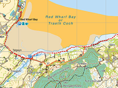
On all Harvey maps, the High Water Mark or the high tide line is shown as a thin blue line. The line can be used as a safety aid for walkers to help them choose when to access coastal areas on long distance paths that integrate beach and coastal rock (such as the Anglesey Coastal Path – see image) or when to use an inland alternative route.
Mapping these lines has never been an easy task as it can often depend on the time of day the aerial photos used for photogrammetry were taken. However, there are several clues to assist in the interpretation of the images and photogrammetrists look for a mixture of natural signs to plot the high tide line. These can range from change in beach slope, drift lines on the beach and the change in colour of coastal rock. There is a significant skill involved in looking for these signs that requires years of practise. During the ground survey stage, these lines are checked and altered accordingly to give the clearest picture to the end user.
Should sea levels rise then not only would those lines need to be recalculated and re-drawn but every black dot (ground survey) spot height on our maps would need to be changed. Whilst contour lines would remain as they are all the contour numbering on every map would have to be adjusted.
Could Ben Vane become a Corbett? Will the Munro, Corbett, Donald and Marilyn tables all have to be re written? Could there be pre and post global warming rounds, the earlier ones being harder with cumulatively several hundred metres more height climbed?
Return to the Navigation Blog


