FREE UK tracked delivery
 Order by 12pm Mon-Fri for same day dispatch
December 2019 - Using the 3rd dimension for navigation
by Nigel Williams
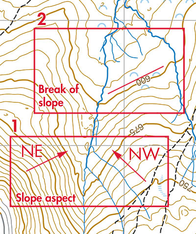
Direction slope faces (aspect) - If I say my kitchen window has a southerly aspect I mean it faces south e.g. 180 degrees. Which direction a slope faces can be determined by taking a bearing directly looking down the slope. Place the compass on the map and move it around with the northing lines in the capsule and the N on the dial pointing to the top of the map and looking to see where the edge of the compass crosses the contour lines at right angles and pointing downhill. An altimeter would confirm which contour we might be on (1 in diagram).
A slope aspect is an invaluable relocation technique if seriously lost. It helps eliminate large swathes of the map where we cannot possibly be. If one is on a north facing slope (we may have several north facing slope options) we can't be anywhere that the contours indicate an east, south or west aspect.
Contours create line features such as ridges and valleys - but look more closely and even a change in slope steepness (break of slope) creates a line parallel to the contours which it is possible to see and follow. In fact it is possible to take a bearing similar to the slope aspect bearing but across the hill side. We can also see and follow the contour line indicating a change in steepness (2 in diagram).
A ridge or spur are linear features. We can therefore use aiming off techniques if there are changes in steepness along the ridge to find a specific point along it when approaching from a valley below.
Ticking off feature - we can keep track of our progress if we can match the ground we are travelling over to the map. Are we crossing contours at right angles or doing a rising traverse - does the ground flatten out briefly before a short steep climb across the contours? Changes in all 3 dimensions can be related to contours.
Catching feature - What does the ground do just beyond what you are aiming for. If you over shoot it is good to have something to stop you promptly and this could be a change in steepness or aspect, and can often be felt if not seen.
Combining an altimeter into our navigation is a powerful addition especially if one is any line feature. An altimeter will immediately tell us where we are along it and therefore our exact position.
Return to the Navigation Blog