FREE UK tracked delivery
 Order by 12pm Mon-Fri for same day dispatch
September 2021 - Advanced Navigation Skills
by Nigel Williams
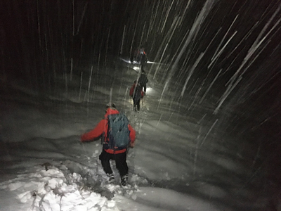
The confidence to walk on a bearing for a specific distance, stopping at no defined point on the map before changing direction and repeating is required, as in the process of "boxing" or making a "dog leg" around a cliff in a winter whiteout where a high level of accuracy is also needed.
Once people have learned to walk with a compass bearing in a straight line in poor visibility across country whilst counting paces to estimate distance, that frequently seems to be the immediate go to solution in all situations. It may be so for a short distance up to about 500m, but not for distances beyond that without a strategy involving "catching features" and "attack points" to help make life easier, even if the distance covered and time required is greater.
Accuracy
The greater the distance travelled on a straight line bearing the greater the error. Over a distance of 1km with pacing accurate to around 90% that would mean plus or minus 100m that gives a 200m band. The compass is inaccurate to around 2.5 degrees. You will have turned the dial, lined up the needle etc. and then you are going to walk over rough ground with it. It is estimated that a variance of 4º either side is likely, which would equate to band width of 140m (it gives a box of 28,000 sqm). That is a sizable area to start searching if you don't have any idea of your position in it and the likely direction of the target. If you lose track of pacing or don't find the destination it suddenly becomes extremely stressful and difficult to sort out as one lacks mapped reference points or landmarks and back tracking will seem very unappealing.
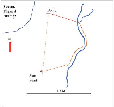
Advanced navigation scenarios are endless and most people will largely avoid requiring them through route choice before leaving home. The diagram and explanation below gives a sense of some advanced navigation processes and how strategy and decision making are more relevant than a compass skill.
It offers a route choice option, in the dark let's say, to go to the bothy using a straight line bearing and pacing with pacing acting as a mental catching feature. Or using a less stressful strategy with a greater chance of first time success, although it is further and will take longer.
First decide the plan, which is best done from the target working back, looking at the attack point and catching feature options. Having done that we could do an accurate bearing on the map for the last part of the leg from the stream junction to the bothy. Let's say 290º is now set on the compass.
Now we can do a rough bearing (without turning the dial) to go roughly 300m NE to hit the stream. We may want to pace or time it but it should be sufficient to do without as the stream itself is our catching feature. We can then relax a bit, hand railing the stream for about 700m and maybe use timing, expecting to reach it in about 10mins. Note that the route crosses the stream after a while in order to help avoid missing the side stream.
At the junction we already have the final leg bearing pre-set and can set off for the last 400m to the bothy without stopping. We have another stream as a possible physical catching feature as well as the options of the mental catching features of pacing or timing.
Slope aspect
If I had to choose one simple skill to master at the advanced level (although introduced in the earlier pieces) it is slope aspect - the direction a slope faces. Stood with your back to slope going up behind you it is possible to point the compass down the slope as accurately as possible such that the direction crosses the imagined contour lines at right angles. Keep the compass steady but bring it level so the needle swings freely, then turn the dial until the red end of the needle points to the N and "Fred (the needle) is in his shed" (the arrow markings on the bottom of the dial). Place the compass on the map, and keeping the lines in the compass dial aligned with the north south grid lines (the N on the dial to the north edge of the map), simply slide the compass around, looking to see where the edge of the compass crosses contour lines at right angles. The needle is irrelevant at this point but if Fred is in his shed then you have the map set as well. Your location will be along the edge of the compass, however there could be a number of places you could be but also a huge area of the map you cannot be. It is a useful first stage of unraveling being misplaced. This gives an area an altimeter (OS Locate) could indicate which contour line you are on.
I also use it in reverse. If I am going around a hill in the mist wanting to descend at a certain point, I take a slope aspect off the map for that line of descent, just a normal bearing process crossing the contours at right angles. In effect I have a pre-set slope aspect. I now walk around the hill with the base plate pointing out from the hill as though taking a slope aspect from the ground. As I progress Fred slowly appears to rotate into his shed at which point I know I can simply descend just focusing on crossing the contours at right angles towards my destination.
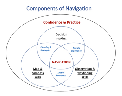
Lockdown boredom research into the science behind our ability to navigate led me to doodle a simple model to try to illustrate the complexity of subject and skills we use. It's a work in progress. All these elements are interlinked. The key to teaching or learning navigation is trying to get them appropriately matched and in context.
Fundamentally, navigation is decision making. There is a lot in that from planning to terrain experience, judgement and confidence.
Observation and way finding are all the navigational skills humans developed before maps and compasses. Spatial awareness and terrain confidence help us create cognitive or mental maps.
Maps and compasses are the tools that interlink with and support the other two main elements.
The 3 elements in blue are the underpinning knowledge and cognitive pathways and processes that link the adjacent elements.
These processes have developed with human (and animal) evolution over many thousands of years. What seems astonishing is that within the space of just 30 years the increasing availability of, and reliance on GPS systems, appears to be eroding many thousands of years cognitive pathway development.
Studies during the last decade have demonstrated that habitual use of the GPS fails to develop our spatial awareness and cognitive navigation processes. Furthermore, it appears that the part of the brain required to interact with the GPS, the caudate nucleus, is the same part of the brain that works when interacting with video games. When the caudate nucleus is engaged it appears to block the development of cognitive pathways and use of the hippocampus which stores our map memory information.
Summary
This series of navigation skills - beginner, intermediate and advanced, is closely related to 3 general levels of terrain confidence; keeping entirely to paths, then exploring short distances off paths and linking linear features. Finally going cross country for multiple legs to point features and often in poor visibility. These are sensible progressions linked to confidence.
The bottom line is we all strive for efficient and accurate navigation within our terrain comfort zone, reducing the error by appropriately integrating all available information and tools.
The good news is that we can all enjoy the outdoors without getting lost and without much technical navigation skill if we choose simple routes on a nice day, keeping the map handy and set so we can follow our progress along the way developing skills and confidence.
Return to the Navigation Blog