FREE UK tracked delivery
 Order by 12pm Mon-Fri for same day dispatch
Cape Wrath Ultra - mapmaker to medallist
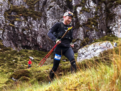
This year, we had extra reason to cheer as former HARVEY cartographer, Lewis Taylor, claimed 3rd place in the men's race! Fresh off the trail, we sat down with Lewis so he could share the highs, lows, and everything in between of his 8 days in the north of Scotland.
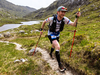
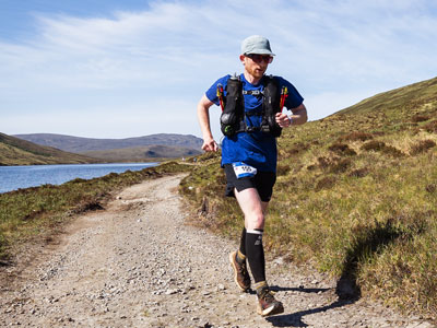
Race photos of Lewis © No Limits Photography.
Why did you want to enter the 2025 Cape Wrath Ultra (CWU)?
I'd started the 2024 race and unfortunately had to pull out due to illness, so I felt like I had unfinished business with it. My motivations for entering the CWU were for several reasons. I'd spent a number of years as a cartographer at HARVEY Maps making the map and dot watching the race, thinking the route looked incredible as it weaved its way up the west coast of Scotland (my favourite place in the world), but I just didn't have the confidence to tackle the distance. Eventually, after gaining more experience with longer distances, I went for it and concentrated on training for eight months with this one goal in mind.
That is such a difficult question because each day is unique. I'm equally torn between day 2 and 4. Day 2 through Knoydart just feels incredibly remote and completely peaceful away from the noise of life. Remote glens, dramatic coastline and high mountain bealachs - it has it all. Day 4 passes through Torridon, which boasts some of the most incredible mountain scenery in Scotland, and coming from an orienteering background, I'm probably one of very few people who enjoyed the 5km of pathless terrain at the back of Beinn Eighe.
Was there a moment when the event map was particularly useful?
Definitely, and for different reasons. Firstly, this year saw an incredibly dry winter and spring for Scotland, so one of the challenges for runners was figuring out where to pick up water en route. I spent some time before the race, looking over the map for those key places I thought would still have running water.
Secondly, I'm a traditional map and compass person and I don't use my watch for navigation because I'm far quicker with a map. Leading up to the race I'd deliberately not set foot on day 6, 7 and 8 because I wanted to experience the terrain for the first time on the race. This is when the map was used on multiple occasions to check my direction, mainly on pathless sections and key junctions. Coming off Ben Dreavie on day 7 was one of those moments. The clag was down so getting the correct line was imperative, in order to not run any unnecessary kilometres!
Most of the time, not much. When I'm running, I tend to switch off. It's the main reason I run most days; it's down-time from life. For this race though, the landscapes are incredible and I enjoyed remembering those times I'd been there before, with friends and family. I had my watch beep at me every 30 minutes to remind me to eat, so I didn't even need to think about that.
What advice would you give to someone who is considering entering an ultra event?
Have a go! Practice with your kit, especially your shoes and socks. Blisters can easily ruin an event. Also practice eating during your long training runs. If you can stomach food through the duration of a race, you're winning! Ultras have been described as eating competitions. I consumed 71 gels over the 8 days, with the maximum being on day 6 when I managed 16.
Tell me about your time at HARVEY Maps
I joined HARVEY Maps in 2015, straight out of university where I studied Physical Geography, and worked as a cartographer for six and a half years. About half way through my final year at university, I emailed Sue Harvey to see if there were any jobs going. A few weeks later, I was up in Doune for an interview and I started just after the summer.
I had a fantastic time working as a cartographer. Within three days of starting, I was off surveying Munros. Over the years, I went on trips to Jura, Mull, the Black Mountains and many more. My favourite part was obviously the survey but I also loved the design aspect of the work. My favourite map I worked on has to be the Jura Superwalker 1:25,000 map. Other than the photogrammetry, I worked on all aspects of the map, from the cartographic editing, map design and the survey. I proudly have a copy on my shelf. It goes without saying, the team at HARVEY Maps were fantastic to work with and they have become lifelong friends.
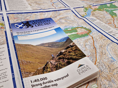
I did. It was a complex map to design, fitting the whole route on one foldable map was tricky. Every year it was always fun trying to decide our favourite photo to put on the cover!
How did you feel when you saw the Cape Wrath Lighthouse, the iconic building that marks the finish?
I got fairly emotional thinking about all the hard work that went into my training over the past two years and the people who helped me get there. It was definitely a team effort.
How have you been celebrating your podium finish?
I celebrated with my team. My wife, son and parents. We had a few drams to celebrate!
Do you have another challenge lined up?
I have nothing planned but plenty of ideas. Maybe a 100-miler next year or I might tackle another 24hr round, such as the Bob Graham Round that I completed a few years ago. For now, I'm going to enjoy some rest. Later this year my wife and I are taking our baby to New Zealand - a 28 hour flight with a 7-month-old... sounds like a challenge!
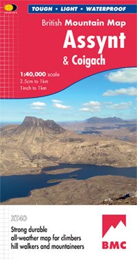
The Cape Wrath Ultra goes through some spectacular parts of north west Scotland - and the terrain is at its finest and most remote in Assynt and Coigach. See the British Mountain Map of the area..
Return to the News & Features Blog