FREE UK tracked delivery
 Order by 12pm Mon-Fri for same day dispatch
Mountain Marathons
by Nigel Williams
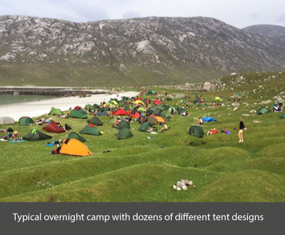
The basic concept is an orienteering event in the mountains for pairs of walkers or runners, over two days, with a remote overnight camp. It is not a specific daily or overall marathon distance. Competitors carry all their camping kit, food, fuel, spare clothing and items of safety equipment shared between them. GPS trackers are not allowed, although altimeters are usually ok. Using some of the lightest equipment on the market and cunning strategies around water, food, and its preparation, the elite competitors get a rucksack down to under 5kg, but the less competitive teams are usually carrying around 9 - 10kg.
Most events offer a range of classes - Elite, A, B, C, D - which have a set order of controls to be visited. D is for beginners and hill walkers and covers about 40km and 2000m of ascent.
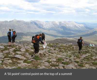
Elite is for some of the country's best fell runners, covering over 60km with about 4000m of ascent. Distances and ascents do vary between events. There are also Score classes - Long, Medium and Short - where you choose which controls to visit, with values from 10 to 50 points, the highest points generally being on the most remote sites or mountain tops. Teams have between 4 and 7 hours to score as many points as possible each day. However, a point is deducted for every minute they are over the time limit, so finishing on time is vital.
The set courses can become a crocodile of teams at big events, but there are route choices between the controls, which can be quite subtle and make a huge difference. I recall one event where the start of the second day had check point 1 on the far side of a long ridge. The straight line route was about 4km, with about 300m of a steep heathery ascent over the ridge and down the other side. An alternative was a 7km route on a track round the end of the ridge with minimal ascent. With great enthusiasm many teams opted for the shortest route over the ridge. We took the long route round to No.1. We realised No.2 was actually on the ridge a couple of kms along from where straight liners were crossing it. As we ascended to No.2 we met a few teams coming down to No.1, cursing the fact they had not seen where No.2 was on the map from the start and were facing a re-ascent of the ridge.
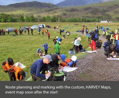
The Score events create a much bigger planning challenge, and your time includes identifying and marking around 20 controls from a list of grid references and then deciding which ones you want to go for.
A good rule of thumb is to estimate the distance from the start to the overnight camp following the easiest line; for example, let's say it is 16km and you travel at a consistent 4kph on the flat and add 90 minutes for the contours crossed going uphill (900m), plus 15 minutes working out all the grid references and route plan. It doesn't always leave a lot of time to go after the more remote and valuable controls that are well off that line.
From that initial plan most of the route and controls to visit will be decided. The top tip is to have cut-off times and places towards the end, and several options, depending on time, to collect a few lower value controls near to the camp. In one event the camp was only about 12km from the start. Many teams went for controls between the two but which would involve a lot of ascent and descent. Not being strong in ascent, we realised there was a good cluster of controls beyond the camp site that we could retreat from if time ran short. We passed the overnight finish and camp at lunch time and collected a healthy score with a little left in the tank for day two.
Score class planners are good at putting a really tempting control about one grid square up a side valley, with maybe 100m of ascent through the heather, quite close to the finish, which often catches the weary out. Exhaustion creeps into poor calculations and decision making. The runners go for it but lose the points by missing their cut-off time. What they often miss is a control on the far side of the finish worth the same value, 1km along a flat easy track. It feels weird to run past the finish but it's worth it and you feel like you have sussed the planners' tricks.
Another favourite is to have two controls 6km apart each side and half way up a mountain. Do you climb extra but have easy running on top, or drop down to the valley, which may be boggy but with kinder weather and possibly a path, before climbing back up? Or avoid climbing altogether by contouring, which may destroy your feet, ankles and knees? These challenges always occur near the end of the day when you are tired and decision-making is at a low ebb.
Planners also like to find route options that may induce parallel errors, such as two very similar ridges or spurs with a control on one of them that the less wary or very tired can confuse and get wrong.
Essential for Mountain Marathon navigation is a good pair of eyes. They need to be observing and taking in as much information as possible, often viewing the lay of the land some kilometres away. It is not just navigation that is important, but also terrain awareness; will it be runnable, bouldery, heathery, boggy etc? One needs to be making micro and macro route decisions that can have a big impact.
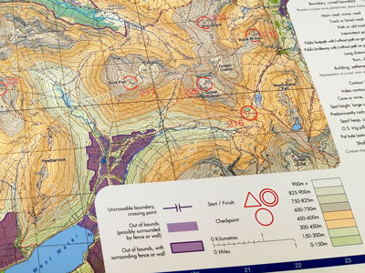
HARVEY Maps has a long association with mountain marathons, with the first KIMM map being commissioned in 1977. The 1:40,000 scale and 15m contour interval is perfect, as these events cover a large area, and the map is clearer to read whilst on the move. In addition, the 1:40,000 scale has room for some 1:25,000 scale information, such as all fence lines and some underfoot terrain information, whilst removing irrelevant navigation information, such as boundary lines.
Mountain marathons are brilliant events and a great challenge. Much of the enjoyment is around the more cognitive planning aspects, meeting lots of like-minded folk, and realising how light you can get your kit. Give it a go, but don't overestimate the class to enter for your first attempt.
Return to the Navigation Blog