FREE UK tracked delivery
 Order by 12pm Mon-Fri for same day dispatch
Refresh your winter navigation skills
by Nigel Williams
Orienteering is a great way to develop navigation skills and confidence beyond the path. Before you dismiss this idea entirely, as you have no intention of wearing lycra and running, the good news is that you don't have to. It is all about the map. We no longer need to attend a competitive event on a given day thanks so many resources we can find online.
British Orienteering has over 650 downloadable Permanent Orienteering Course (POC) maps across the UK on the www.goorienteering.org.uk website. In the woods there are permanent markers for you to find and navigate between. Choose any points to visit in any order so you can design a nice forest path walk and have a bit of a challenge along the way. On the Scottish Orienteering website there are around 300 virtual orienteering course all across Scotland, mostly in urban areas.
Getting to grips with contours
Contour lines show two things, steepness and slope aspect (the direction a slope faces) and together they create the topography of the landscape. Numbers just show height above sea level. Aspect is indicated by standing with your back to the up hill slope facing out and looking down; imagine the line a huge ball bearing would take if you could roll it down the hill, effectively crossing the contours at a right angle. Simply use the compass needle to estimate that direction and check it on the map just using the cardinal points, or take a bearing on it for greater accuracy if required.

Imagine B is a small stream junction. Following the contour line directly may be a poor strategy; if you don't hit the junction will you go up or down the stream to find it? The strategy of 'aiming off' is needed. It is always easier descending to a feature, as you get a better view of the terrain looking down. In this scenario, climb a contour or two, then traverse along the contour line and, at the stream, descend to the junction. It may seem like 3 sides of a square but is likely to be more efficient. If A and B are at different heights simply follow the contour line from A to the stream and climb or descend as required, the 'aiming off' concept is already built in. If B was a small point feature, such as a boulder on an orienteering map, then we need to pace to an imaginary point, ideally directly above the boulder, so our descent is exactly straight downhill, crossing the contours at right angles, which is the most natural descent line and easy to feel.
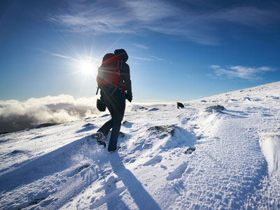
Additional winter skills
In winter above the tree line we can lose valuable 'handrail features' such as footpaths and streams, so contour interpretation plays a really significant role. We need to be aware of what the ground should feel like. Will it steepen or flatten? If the hillside bends around, changing the slope aspect, I may go from feeling that I'm crossing the contours diagonally to crossing them at right angles - I can feel that change and estimate my position from it.
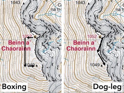
Consider the two pictures above. With the 'boxing' scenario we might notice the slope aspect change from W to SSW if we go too far on the long southerly leg, Using the 'dog leg' may be a better option, as we might feel the change in the slope at the end of first leg, and if we overshoot 1049 we are less likely to walk over the edge. It is useful to have a pen to mark a dot on the map to align the compass on for the bearings.
Being able to see your footprints in the snow can be a help with pacing, which can be significantly affected by the underfoot conditions. The distance between my heel and toe when I take a single step is roughly the length of my boot - I can see if it becomes halved as I climb or if the snow is deep, that adds 50% to my pacing and heel to toe footprints double my pacing. It works for most people.
Along with all the skills and strategies there is a third key element in all this - CONFIDENCE. Using an Orienteering map in the woods offers lots of opportunities to practise, experiment and make mistakes with limited visibility but in a safer environment. There is usually plenty of route choice, needing navigation strategies such as 'aiming off', balancing 'attack points' with 'catching features' to find the target and decisions around using mental catching features - pacing and timing or physical ones such as a stream or a change in the slope. Navigation is a multi-tasking decision-making process which needs a good degree of confidence and we can't be confident doing something we don't practise.
- For more advice on winter navigation, take a look at Nigel's blog from December 2021, Tips on navigating in a winter white out
- If you are in need of a compass then we stock a great range of items and other useful navigation equipment, suitable for all levels of navigation.
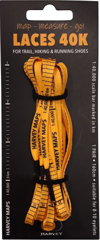
- For the perfect lanyard to go with your compass, the HARVEY Map - Measure - Go! scale bar laces double up to make measuring distance easy! Available in two scales, 1:25,000 scale markings (red) and 1:40,000 scale markings (yellow).
Return to the Navigation Blog